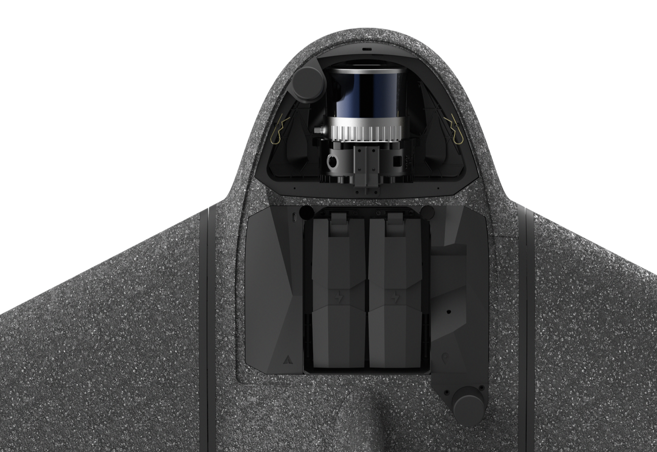
Marlyn Cobalt with Lidar sensor

Drone Surveying Sensors

With Marlyn’s quick swap payload system you’re ready to survey in minutes.

Atmos LiDAR

Operating in vegetated areas or working on projects where you need a straight-to-point-cloud workflow? Then look no further! The Atmos Lidar is a custom-assembled spinning laser, the most accurate LiDAR and IMU that is currently equipped on a VTOL drone.
Lowest GSD
Megapixel

Precision 2 - 3 cm

Vertical Accuracy 2 - 4 cm

Range Up to 150 m

Effective Point Rate 178,000 pts/s

Point Density at 100m 53 pts/m² [4.9 pts/ft²] (Single Return)

FOV (Horizontal) 105°

FOV (Vertical) 40.3°

Scan Angle (Vertical) -20.8° to 19.5°

Marlyn Cobalt LiDAR Payload

Need more LiDAR info?

Contact us to see datasets, specs
and to discuss your own project needs.

Contact Us
No items found.
No items found.
No items found.
No items found.

Performance Calculator.

6000
4000
23.5
12
60
75
Ultra high resolution = 1 cm/px
Ultra high resolution = 0.4 inch/px
1
30
Atmos LiDAR
9504
6336
35.7
21
60
75
Ultra high resolution = 1.6 cm/px
Ultra high resolution = 0.6 inch/px
0.6
30
Sony A7RIV
6000
4000
23.5
12
60
75
Ultra high resolution = 1 cm/px
Ultra high resolution = 0.4 inch/px
1
30
Sony A6100
2464
2056
8.325
10.3
60
75
Ultra high resolution = 2 cm/px
Ultra high resolution = 0.79 inch/px
2
25
MicaSense RedEdge-P
4112
3008
14.18
16.3
60
75
Ultra high resolution = 1.3 cm/px
Ultra high resolution = 0.5 inch/px
1.3
25
MicaSense Altum PT
m
m
cm/px
Ultra high resolution = 1.6 cm/px
Calculate
Thank you! Your submission has been received!
Oops! Something went wrong while submitting the form.
Images captured:
0
Flight time (Mins):
0
Altitude (m):
0
Ultra high resolution = 1cm/px
Reset
(Calculations based on a 60% Sidelap)

Selected for Accuracy & Quality

Our sensor line-up represents the best possible sensors on offer for drone surveying. Combined with our integrated Topcon PPK, you get the best possible accuracy each time you go out.

Thoroughly tested with 100’s of flight hours.

For true accuracy and absolute reliability, all of Marlyn's sensors are thoroughly tested in the field for a wide variety for use cases and situations. This means you get data that works for your project!

Ready for Future Upgrades

We believe in keeping our users current, so with Marlyn's modular payload arrangement when the time comes for future payloads, your Marlyn is ready to expand into new possibilities of surveying.

Frequently Asked
Questions

Does that purchase price include software for the lidar processing?
The purchase price includes the first year of the annual software license.
Are there any major differences from flight planning a Lidar flight to a Photogrammetry flight in Navigator?
No, you may use the same workflow as planning a standard mission. Marlyn will still need to fly lines with a spacing in between for a fixed overlap.
Is the Lidar payload backwards compatible with existing Marlyns?
The Atmos LiDAR payload is compatible with all Marlyns that can carry the A7R4 (wrapped wings with shortened rods). To confirm compatibility contact sales.
Is it necessary to purchase PPK with a Lidar Marlyn?
No, the LiDAR contains its own GNSS receiver and is fully integrated in the payload. When flying with multiple payloads, the PPK module needs to be removed and swapped for the LiDAR specific module, containing a secondary antenna.
I have a question

Continue Exploring