Modernizing Land Administration with Mapping Drones: Accelerating Boundary Surveys
Modernizing Land Administration with Mapping Drones: Accelerating Boundary Surveys
Modernizing Land Administration with Mapping Drones: Accelerating Boundary Surveys
Modernizing Land Administration with Mapping Drones: Accelerating Boundary Surveys
Valkenburg
Thursday, August 31, 2024
Unmanned aerial vehicles are reshaping traditional processes in land management procedures that have historically been slow and resource-intensive. In this blog, we delve into the role of mapping drones in revolutionizing cadastral boundary surveys and land administration.
What’s a Rich Text element?
The rich text element allows you to create and format headings, paragraphs, blockquotes, images, and video all in one place instead of having to add and format them individually. Just double-click and easily create content.
Test
Static and dynamic content editing
A rich text element can be used with static or dynamic content. For static content, just drop it into any page and begin editing. For dynamic content, add a rich text field to any collection and then connect a rich text element to that field in the settings panel. Voila!
How to customize formatting for each rich text
Headings, paragraphs, blockquotes, figures, images, and figure captions can all be styled after a class is added to the rich text element using the "When inside of" nested selector system.
test
H1
H2
H3
H4
H5
Headings, paragraphs, blockquotes, figures, images, and figure captions can all be styled after a class is added to the rich text element using the "When inside of" nested selector system.
Land administration is undergoing a transformation with the advent of mapping drones. These unmanned aerial vehicles are reshaping traditional processes and expediting land management procedures that have historically been slow and resource-intensive. In this article, we delve into the role of mapping drones in revolutionizing cadastral boundary surveys and land administration.
The Imperative for Enhanced Land Administration
A significant portion of the global population lacks access to proper land administration services, which results in insecurity of land tenure. This not only hampers sustainable development but also has far-reaching impacts on taxation, service delivery, and urban growth, often leading to conflicts and unplanned expansion. The urgency to address this issue is underscored by Sustainable Development Goals (SDGs) 1.4 and 2.3, which emphasize equal property rights and secure access to land.
The Fit-for-Purpose Approach
To overcome the challenges posed by conventional labor-intensive land administration methods, the Fit-for-Purpose Land Administration (FFPLA) system has been introduced by collaborative efforts from the World Bank and the International Federation of Surveyors (FIG). This innovative approach offers flexibility by focusing on visible physical boundaries and leveraging remotely sensed data, such as that obtained from satellites, aerial surveying aircraft, and drones. Notably, the FFPLA approach has the potential to reduce costs by up to three to five times compared to traditional field surveys.
Spatial framework
Legal framework
Institutional framework
Visible (physical) boundaries rather than fixed boundaries.
Aerial/satellite imagery rather than field surveys.
Accuracy relates to the purpose rather than technical standards.
Demands for updating and opportunities for upgrading and ongoing improvement.
A flexible framework designed along administrative rather than judicial lines.
A continuum of tenure rather than just individual ownership.
Flexible recordation rather than only one register.
Ensuring gender equity for land and property rights.
Good land governance rather than bureaucratic barriers.
Integrated institutional framework rather than sectorial silos.
Flexible ICT approach rather than high-end technology solutions.
Transparent land information with easy and affordable access for all.
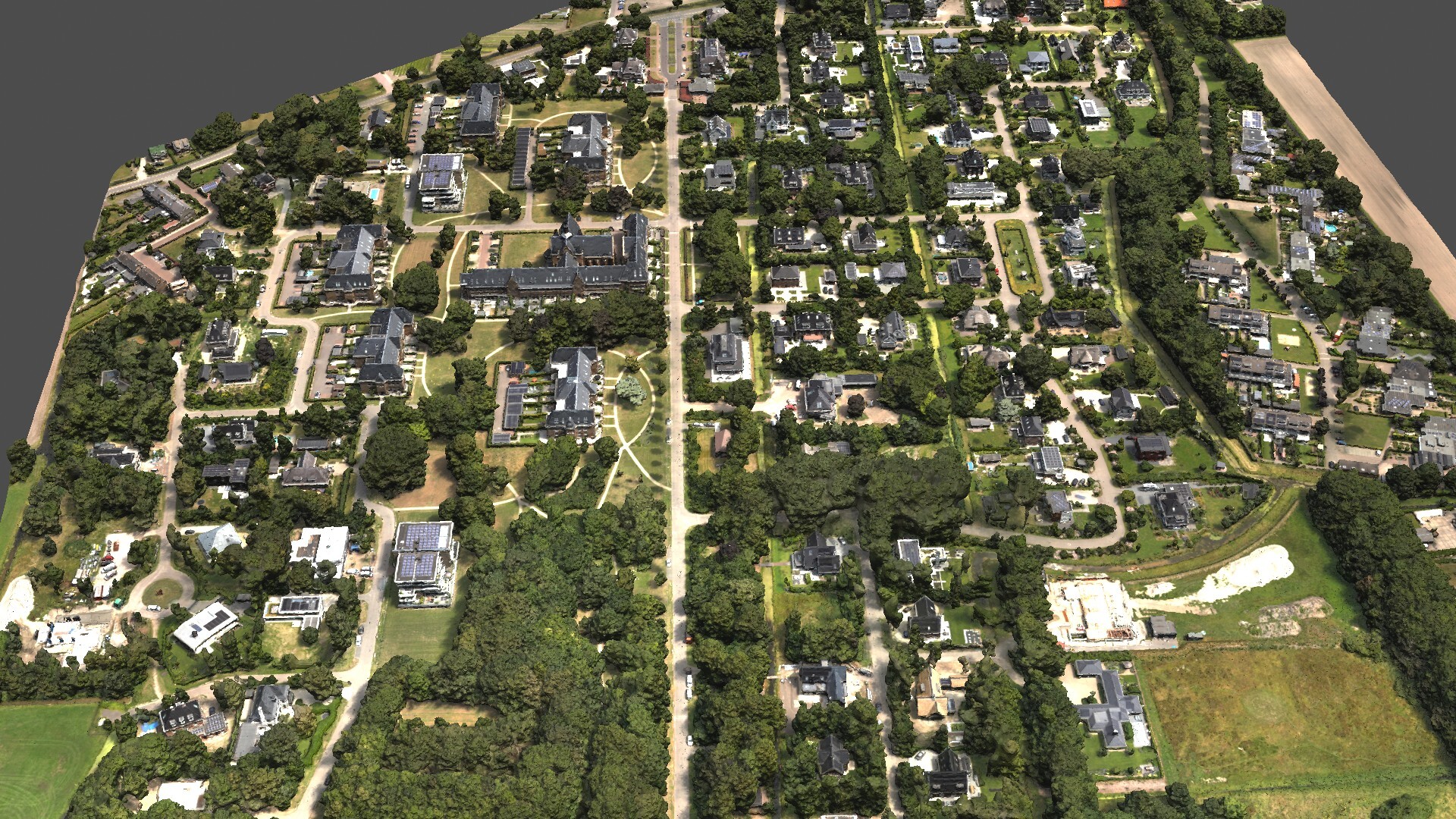
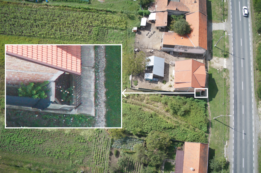
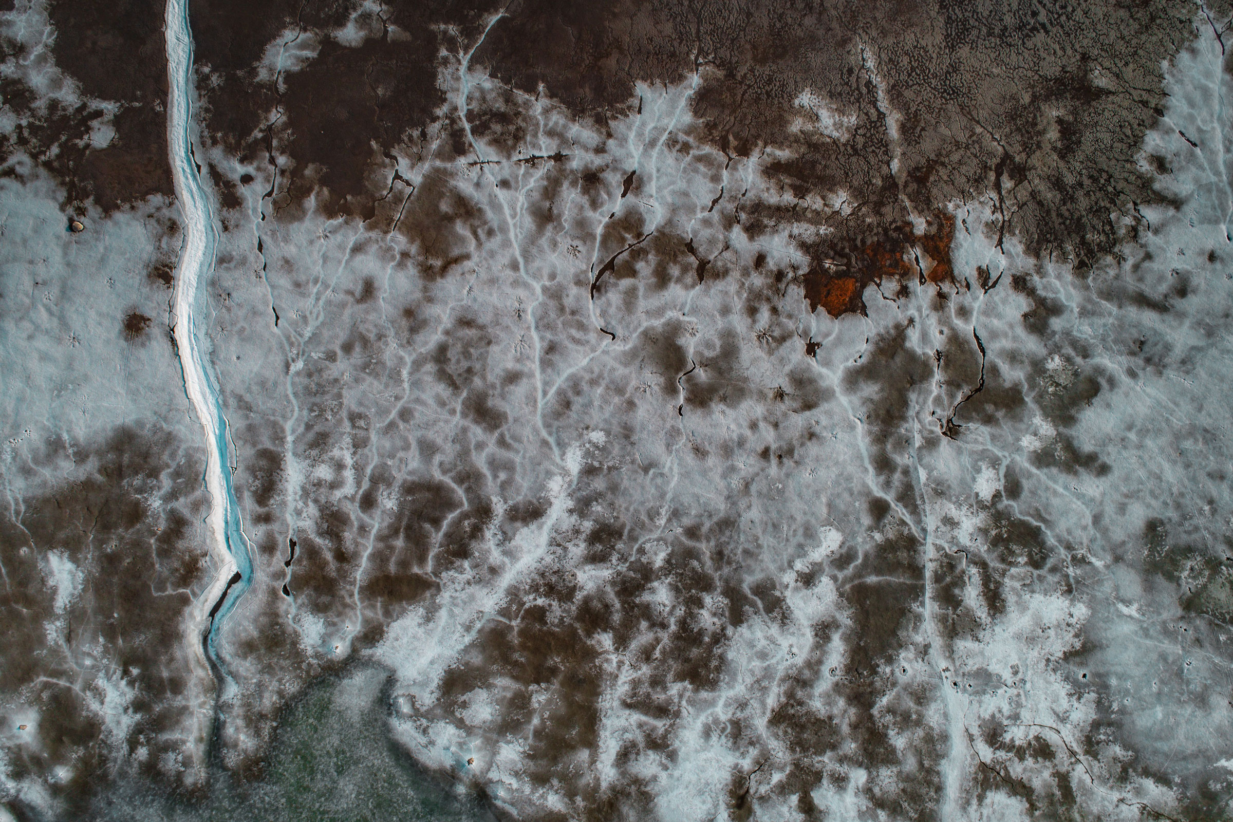
Mapping drones equipped with advanced cameras and sensors have emerged as game-changers in cadastral mapping. These unmanned aerial vehicles can rapidly capture high-resolution imagery from various angles, covering vast areas in a fraction of the time required by conventional methods. This high spatial resolution enhances accuracy in detecting and marking objects such as fences and other physical boundaries. The effectiveness of mapping drones is showcased in their ability to capture even intricate structures like fences with exceptional clarity.
Visibility of a fence on an aerial picture from Atmos Marlyn
Harnessing Drone Technology for Cadastral Surveys
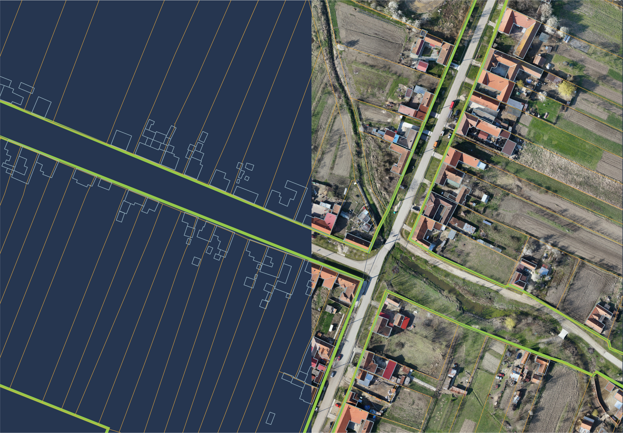
Aerial surveying drones offer georeferenced aerial imagery that can be processed into point clouds and orthophotos. These data sources enable the identification and delineation of cadastral boundaries corresponding to physical features like fences, walls, and roads. Beyond spatial information, aerial imagery also provides insights into land utilization, infrastructure, and buildings, facilitating urban planning and development.
Example of an orthophoto (right) from which the house perimeters and parcel boundaries are identified (left). The orthophoto was created using data captured by Atmos' Marlyn Cobalt UAV
Vectorization of Drone Data
Processing aerial survey drone data often involves generating georeferenced orthophotos and manually vectorizing objects using specialized software. Alternatively, raw imagery combined with point clouds can be used. This approach offers more detailed information than orthophotos, which is particularly advantageous for tasks like vectorizing building walls.
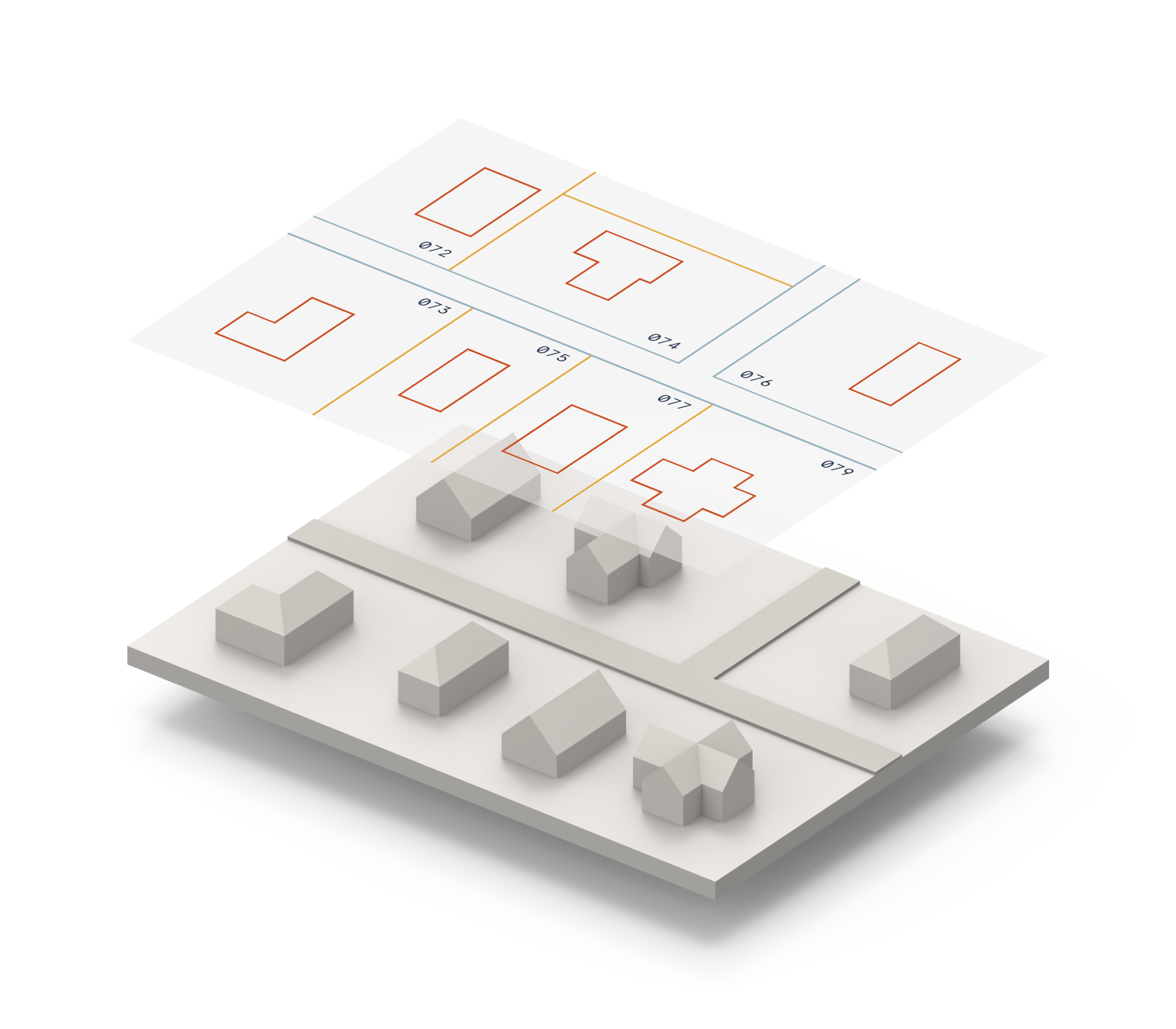
Illustration example of vectorized data
Automated Tools and Precise Results
Experimental tools employing advanced algorithms can automatically detect and mark key features within drone imagery, producing vectorized images that clearly represent house perimeters and land plots. The output is a set of 2D drawings that exhibit remarkable accuracy, presenting a comprehensive overview of property layouts, boundaries, and spatial relationships. These drawings serve as valuable references for land administrators and urban planners.
Conclusion
The integration of mapping drones into land administration processes, particularly in the realm of cadastral surveys, is transforming the efficiency and accuracy of boundary determination. Innovations like the FFPLA approach, combined with advanced drone technology, hold the potential to expedite land use and infrastructure development. As technology continues to evolve, the collaboration between modern methodologies and mapping drones will undoubtedly redefine the landscape of land administration.